Using Satellite Data to Help Communities on the Ground
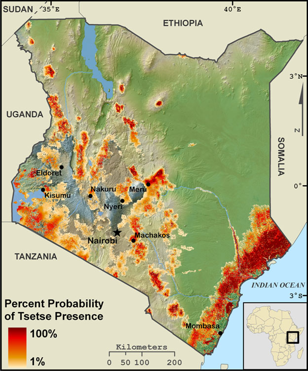
Percent Probability of Tsetse Presence
[click for larger view]
- Joseph P. Messina, Ph.D.
- Professor, Department of Geography, Environment, and Spatial Sciences
- Associate Dean for Research
- College of Social Science
Joe Messina is known in many quarters for his work using geographic information to map tsetse fly habitat in Africa, putting an important tool in the hands of governments seeking to curtail the spread of the parasites that cause sleeping sickness. With geographic information systems (GIS) (computer systems that a researcher uses to gather, organize, and display geographic data) and remote sensing (extracting information without being in direct contact with the subject, often using satellites or drones), Messina has been very successful in identifying actual and potential tsetse fly habitat.
Messina is more than the "tsetse fly guy," however, as he and his graduate students continue to work with governments, communities, and researchers around the world, applying geographic data to important local issues—from agricultural resilience in the face of climate change in Southeast Asia to determining whether a community should build a new hospital in southeast Michigan. Their work illustrates how a constellation of relationships and partnerships propels research forward.
Precision Agriculture for Smallholder Systems in Africa
As Messina defines the term, smallholder farmers are those who are primarily subsistence farmers. Though they may produce a small cash crop, they are primarily farming to feed their families. In Malawi, Messina has a project sponsored by the United States Agency for International Development (USAID) that seeks to help farmers make better informed decisions to increase productivity.
"The project is taking something that's super high-tech, basically drone-based and satellite-based remote sensing, and converting it into information that would be useful for a poor farmer in Africa," Messina said.
For this project, he is partnering with an agronomist and an economist. His responsibility is to collect geographic data and determine where and when to apply various agricultural strategies to maximize farm productivity. His partners will use that information and make recommendations based on what should be done from an agricultural point of view and what can be done from the economic perspective. Each of these is critical. Farmers not only need good data, they need good agricultural advice that is also economically feasible. As Messina explains, it's one thing to say: "'Oh, you have to put on a whole bunch of fertilizer,' but, if farmers don't have enough money to buy fertilizer, you're not helping."
Messina hopes to streamline the process so that recommendations can be made in real time, rather than retrospectively. He expects that they will figure out a way to automate the process of collecting the data and converting it into a limited set of actionable information.
"I am trying to make this actionable information as opposed to an after-action response or report," Messina said. "Why did a crop fail? I don't really care about that. I want to know how can I make the crop better. Now."
The proposed system will help farmers maximize crop yields with information they can act on immediately. Because most shareholder farmers do not have the capacity to access the information they will provide, Messina anticipates that partnering with Malawi's Extension Planning Area (EPA) officers will facilitate communications with those small shareholders on their rural farms, and allow the research data and critical information to reach those who will most benefit from it.
Predicting Critical Climate Changes that Affect Crop Productivity in Asia
In Southeast Asia, Messina and his researchers have set up weather stations on small shareholder farms in order to get a more granular look at local weather. The sites were chosen because they sit on the margins of climate regions. The idea is that climate change will have a significant impact on what grows where in the long run, but at the margins the effects of climate change may come sooner.
To illustrate, he points to apple orchards in Michigan, where apples will comfortably grow for the next hundred years, even with the worst climate change projections.
"The issue is that in a lot of places, though, what we're growing might change," he said. "Again, using Michigan as an example, we might see wine grapes moving up into the U.P. But it's marginal for wine grapes right now. I'm interested in these places in Africa, for example, or Southeast Asia where it's marginal for the primary crop."
Corn is grown everywhere, he said, because of the caloric yield per acre. In a lot of places, however, there is barely enough rainfall to support a corn crop year after year.
"If you're in a place where the rainfall is at the low end, a little shift, which might be in that realm of reasonable for climate change in the near term, will make a big difference," he explained.
The weather stations will help Messina and his lab understand the local-scale drivers and perhaps allow researchers to find ways to mitigate the effects of climate change.
Student Learning on the Ground
Four of the students in Messina's lab have been in the field in Malawi. Their work illustrates the partnerships and relationships critical to their research.
April Frake is looking at the impact of land use and land cover change (LULCC) on human health. In particular, she is asking whether the current approach to addressing food security—turning more land over for irrigated agriculture—is negatively impacting human health by providing more habitat for malaria-carrying mosquitoes throughout both the rainy and dry seasons.
Frake's research site is the Bwanje Valley Irrigation Scheme (BVIS) and surrounding area, located in central Malawi. The BVIS was established in 2000 to increase the production of certain crops—like rice, maize, soybean, and cowpea—through irrigation. This means Frake can compare probable mosquito habitat in the scheme with the surrounding region.
Her partners in Malawi include fellow researchers from the Lilongwe University of Agriculture and Natural Resources (LUANAR), the University of Malawi, and, in a less formal sense, the estimated 2,000 small shareholder farmers who grow crops in the scheme.
"Often farmers are curious as to why I am there and what I am doing," Frake said. "These opportunities allow me to share with them briefly how the surveys I am conducting work to inform our understanding of agricultural growth and mosquito development across the scheme."
From the farmers, she learns about their experience participating in the BVIS—how long they've been members, what they are growing, and how the scheme has impacted the economy and helped them economically. Many of these farmers are participants in a larger malariometric and vector survey Frake is a part of in the area's surrounding villages, so they also often share the experiences they and their families have had with malaria. (This is the NIH FRAME Malaria Survey at Bwanje Valley Irrigation Scheme. The project is a collaboration between MSU, LUANAR, and the University of Malawi. Researchers are testing the hypothesis that transforming land for irrigated agriculture increases malaria vulnerability for those residing in close proximity to irrigation schemes. The project includes faculty members from each of these institutions along with six post-doctoral fellows.)
"Environmental change is often rooted in human decision making," she said. "Through building relationships with farmers in the local area I am able to better understand the thought processes and drivers behind some of these decisions at the local scale and in turn reflect on how they may impact my larger research questions."
Brad Peter is another of the doctoral candidates in Messina's lab. His work focuses on improving agricultural systems by integrating remotely-sensed data with crop modeling. The primary site for his research is Malawi, though the models he's developing can be applied more broadly to East Africa and the African continent.
"The overarching objective of my dissertation is to improve agricultural systems by integrating remotely-sensed data with crop modeling, ultimately to recommend improvement applications that are informed by spatiotemporal analytics of crop performance," Peter said. His research proposes maps and methods that illuminate the scaling potential of various agricultural improvement strategies. At the center of this work is the smallholder farm.
"The reason for focusing on these areas is that population pressure, soil exhaustion, and climate change have led to food shortages across the African continent, particularly in Sub-Saharan Africa and Malawi," Peter said. "Remote sensing data offer information in remote areas where fine resolution on-the-ground data are not collected regularly."
In the field, Peter works with colleagues from LUANAR and Africa RISING (Research in Sustainable Intensification for the Next Generation). They provide valuable connections to local farmers and Extension Planning Area officers.
"These relationships are necessary to be effective in the field," he said.
When Peter is in Malawi, he often talks with farmers about his research, but the real work is the relationship with the Extension Planning Area officers, who have deep knowledge of their respective agricultural areas.
"The data that the weather stations have been collecting over the last couple years are currently being used by agronomists and crop modelers to monitor agricultural response to climatic drivers," Peter said. In the lab, the weather station data, collected in Malawi, are being linked with satellite measurements in order to develop more robust soil moisture models.
Teaching Others to Work with Big Piles of Data
A critical piece of all these research projects is the collection of lots of data, which are then organized and interpreted, and from which models are developed—all with the aim of making very technical information useful for non-technical users. Experience with this kind of translational work has led others to seek out Messina's expertise.
"I get lot of requests to talk about how to manage big piles of data," Messina explained. "What does that look like? How do we translate all this high-tech stuff to people in the rest of the world?"
Lately, Messina has been educating all sorts of people about how he applies his research. Through conversations with organizations like the International Center for Tropical Agriculture and the International Livestock Research Institute—both United Nations' Consultative Group for International Agricultural Research (CGIAR) centers—Messina's approach is finding an audience beyond his lab at Michigan State.
- Written by Matt Forster, University Outreach and Engagement
- Photograph courtesy of MSU Communications and Brand Strategy
- Map Image courtesy of Joseph P. Messina